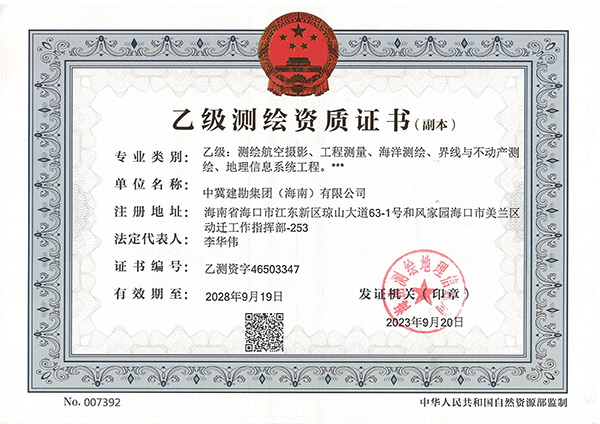
Under the leadership of the Group Company, through the careful operation of the Engineering Surveying Company and the Safety Production Department, China Hebei Construction & Geotechnical Investigation Group (Hainan) Ltd. obtained the Class B Surveying and Mapping Qualification issued by Hainan Administration of Surveying, Mapping and Geoinformation on September 20, 2023, the qualification includes five specialties: aerial photography for surveying and mapping, engineering surveying, marine surveying and mapping, boundary and real estate surveying and mapping and geographic information system engineering.
This qualification has laid a solid foundation for the expansion of the surveying and mapping business of Hainan Company, and added new wings for the business of Hainan Company to move towards nationalization and internationalization.
The scope of business that can be undertaken includes:
1. Surveying and Mapping and Aerial Photography: general aerial photography, unmanned aerial vehicle aerial photography, tilt aerial photography.
2. Engineering Surveying: control surveying, topographic surveying, planning surveying, architectural engineering surveying, deformation and precision surveying, municipal engineering surveying, water conservancy engineering surveying, line and bridge-tunnel surveying, underground pipeline surveying, mine surveying, and engineering surveying supervision.
3. Marine Surveying and Mapping: coastal topographic surveying, bathymetric surveying, hydrographic observation, marine engineering surveying, sea-sweeping surveying, sounding datum surveying, nautical charting, and supervision of marine surveying and mapping.
4. Boundary and Real Estate Surveying and Mapping: administrative boundary surveying and mapping, cadastral surveying and mapping, property surveying and mapping, maritime domain surveying and mapping, real estate surveying and mapping supervision.
5. Geographic Information System (GIS) Engineering: geographic information data collection, geographic information data processing, geographic information system and database development, ground mobile surveying, geographic information software development, and geographic information system engineering supervision.